![](/images/other/stat-length.png)
![Tocht Te voet la Vall d'en Bas - L'altiplà de Collsacabra - Photo](https://media.geolcdn.com/t/1900/400/9c0f392b-debf-4f1f-83d3-e449334c7854.jpeg&format=pjpeg&maxdim=2)
L'altiplà de Collsacabra
SityTrail - itinéraires balisés pédestres
Tous les sentiers balisés d’Europe GUIDE+
![Lengte](/images/other/stat-length.png)
![Max. hoogte](https://static1.geolcdn.com/siteimages/upload/files/1508320355ic_sort_altitude_max_24dp.png)
![Positief hoogteverschil](https://static1.geolcdn.com/siteimages/upload/files/1508320355ic_sort_den_pos_24dp.png)
![Km-Effort](/images/other/stat-length.png)
![Min. hoogte](https://static1.geolcdn.com/siteimages/upload/files/1508320355ic_sort_altitude_min_24dp.png)
![Negatief hoogteverschil](https://static1.geolcdn.com/siteimages/upload/files/1508320355ic_sort_den_neg_24dp.png)
![Boucle](https://static1.geolcdn.com/siteimages/upload/files/16400158638029165_repeat_loop_refresh_sync_direction_icon.png)
![Te voet](https://static1.geolcdn.com/sitytour/trail-icons/100.png)
4h03
Moeilijkheid : Gemakkelijk
![Scan deze QR-code om de tocht te openen in de SityTrail-applicatie](https://capi.geolives.com/qq0zvz2zws4bq2lad0pu/sitytour/trails/3110513/qr.png?size=200)
Gratisgps-wandelapplicatie
Over ons
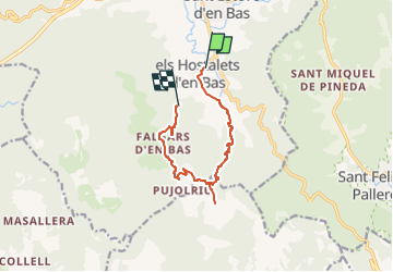
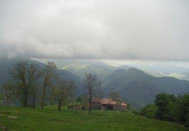
Tocht Te voet van 10,9 km beschikbaar op Catalonië, Gerona, la Vall d'en Bas. Deze tocht wordt voorgesteld door SityTrail - itinéraires balisés pédestres.
Beschrijving
Aquesta ruta segueix una part del camí ral entre Vic i Olot, una via medieval que uneix aquestes dos ciutats i que sembla que fou acondicionada amb la finalitat de proveir de fusta a la ciutat de Barcelona.
Website: https://www.itinerannia.net/ca/itineraris/per-l-altipla-del-collsacabra-ruta-4-garrotxa/
Plaatsbepaling
Opmerkingen
Wandeltochten in de omgeving
![Tocht Te voet Sant Feliu de Pallerols - Sant Feliu de Pallerols-Sant Pere Sacosta-La Salut - Photo](https://media.geolcdn.com/t/375/260/7f1e2cfe-5af5-4dc5-8aea-94a2c3bbae2b.jpeg&format=jpg&maxdim=2)
![Te voet Te voet](https://static1.geolcdn.com/sitytour/trail-icons/100.png)
Te voet
![](/images/other/stat-length.png)
![](https://static1.geolcdn.com/siteimages/upload/files/16400158638029165_repeat_loop_refresh_sync_direction_icon.png)
![Tocht Te voet les Preses - Ermites del Corb - Photo](https://media.geolcdn.com/t/375/260/0fb801a8-893d-44a1-841b-eb19e7e06469.jpeg&format=jpg&maxdim=2)
![Te voet Te voet](https://static1.geolcdn.com/sitytour/trail-icons/100.png)
Te voet
![](/images/other/stat-length.png)
![](https://static1.geolcdn.com/siteimages/upload/files/16400158638029165_repeat_loop_refresh_sync_direction_icon.png)
![Tocht Te voet la Vall d'en Bas - Mirador de la Vall d'en Vas i la Garrotxa - Photo](https://media.geolcdn.com/t/375/260/75a9f504-f2a6-457a-9e5b-11bf93723068.jpeg&format=jpg&maxdim=2)
![Te voet Te voet](https://static1.geolcdn.com/sitytour/trail-icons/100.png)
Te voet
![](/images/other/stat-length.png)
![](https://static1.geolcdn.com/siteimages/upload/files/16400158638029165_repeat_loop_refresh_sync_direction_icon.png)
![Tocht Stappen la Vall d'en Bas - Massif Puigsacalm, Joanetes - Photo](https://media.geolcdn.com/t/375/260/ext.jpg?maxdim=2&url=https%3A%2F%2Fstatic1.geolcdn.com%2Fsiteimages%2Fupload%2Ffiles%2F1553511878bg_sport_marche.png)
![Stappen Stappen](https://static1.geolcdn.com/sitytour/trail-icons/101.png)
Stappen
![](/images/other/stat-length.png)
![](https://static1.geolcdn.com/siteimages/upload/files/16400158638029165_repeat_loop_refresh_sync_direction_icon.png)